
End-of-Summer Sale: 25¢ for 3 MonthsSave on unlimited digital access. Sale Ends Aug. 24 |
More tropical trouble brews in the eastern Atlantic in Erin's wake. Here's what we know
Erin, the 2025 Atlantic hurricane season’s fifth named storm but its first hurricane, became a monster Category 5 storm over the weekend, with maximum winds of 160 mph. As Erin sideswipes the Bahamas on Monday, it isn’t the only tropical system being monitored by the National Hurricane Center, writes newsroom meteorologist Justin Ballard.
A tropical wave of low atmospheric pressure in the far eastern Atlantic has a 50% chance of developing into a tropical depression by early next week, according to the hurricane center. The system is expected to move westward this week, taking a path similar to Erin toward the Caribbean Sea.
If the tropical system takes more southerly course than Erin's, it could enter the Caribbean, which increases the chances of a potentially devastating direct landfall in a populated area. But a more northerly development track, Ballard writes, would likely keep the system in the Atlantic and would present a more challenging route into the Gulf of Mexico.
Tropical disturbances this deep in the Atlantic typically take 10 or more days to reach the United States, according to Ballard.
READ MORE: Hurricane Erin lashes Bahamas as forecasters eye new tropical threat in Atlantic Ocean on Monday
 | Roberto Villalpando, Texas Weather Science Editor |
Justin's Five Day Fit Check
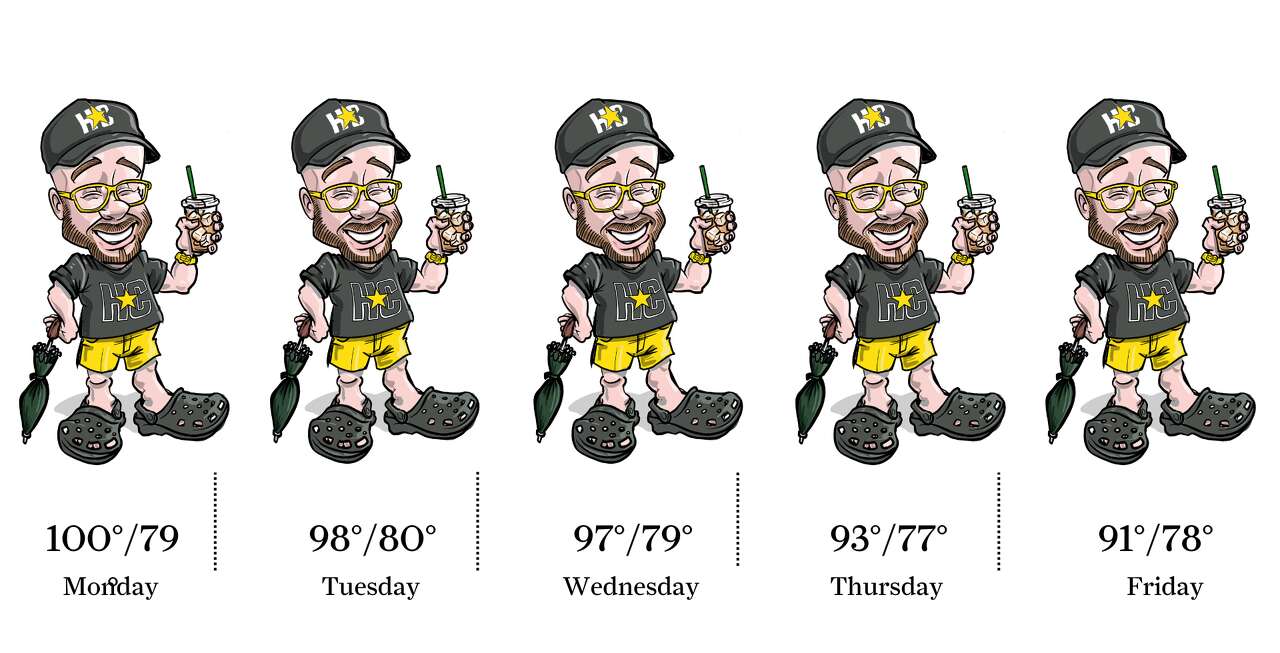
Photo by: Ken Ellis
Houston is in store for another hot and occasionally stormy week. The hottest weather the Space City can expect occurs through Wednesday with daily highs in the upper 90s. If clouds and storms don’t bubble up too early in the day, Houston temps could touch 100 degrees a time or two this week. Scattered daily storms also are expected to gather during the afternoon and early evening.
 | Ask a Meteorologist |
Why aren’t direct sunlight temperatures reported alongside official observed temperatures, which are measured in the shade?
Reader Kathy H. asks a great question and one that I’ve addressed occasionally. It is true that observed temperatures you see in each day’s weather reports are measured in the shade.
Official temperature measurements across the country, collected at airports and other sites are measured in a shaded instrument box to keep weather data consistent. This standard measurement technique is also used to determine heat index values, a particularly important aspect of the summertime forecast in Houston.
If one were to use a thermometer to take measurements in direct sunlight, the tool being used to assess temperatures would absorb incoming solar radiation that would skew readings of the actual air temperature. Direct sunlight temperatures can be as much as 10 to 15 degrees warmer than temperatures collected in the shade. This means a high of 95 may feel more like 110 degrees in direct sunlight, not considering the influence of heat index, which could add 10 degrees or more to the temperature reading.
So, why are two temperatures not reported more often, one in the shade and one in direct sunlight? It’s a fair question and one that should be considered when discussing the forecast going forward, particularly during the hot summer months.
READ MORE: Houston's oldest commercial airport provides rare look at how weather data is collected
Do you have a Houston weather or climate question? If so, you can submit your weather questions to justin.ballard@houstonchronicle.com. They may just end up in a future edition of the weather newsletter.
Something to see
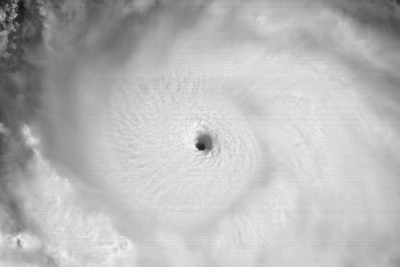
Photo by: Geostationary Operational Environmental Satellites, CIRA And NOAA
This weather satellite image captured over the weekend on Aug. 16 shows the clearly defined eye of Hurricane Erin as the storm strengthened into a Category 5 hurricane with maximum sustained winds of 160 mph, passing just north of the Leeward Islands in the western Atlantic Ocean. Erin is the first named storm of this year to become a hurricane.
Texas Weather Wonks Trivia
Houston’s official climate observation site at Bush Intercontinental Airport on Sunday recorded only its sixth 100-degree day so far this year. What is the most recent year that Houston went without recording any 100-degree days for the entire 12 months?
A) 2021
B) 2017
C) 2014
D) 2006
Hit reply to this email to let us know what your guess is and a chance to win. We’ll let you know who answered correctly first in next week’s newsletter.
Janice Holley had the correct answer to last week’s trivia question: In Houston’s second-driest August, only 0.01 inch of rainfall was reported — what year was that? It’s D) 2023
Other weather news
|

|

|

|

|
Meet the Team

Photo by: Susan Barber
The 713 Weather Radar newsletter is written and produced by meteorologist Justin Ballard and Texas Weather Science Editor Roberto Villalpando. You can reach out to them at justin.ballard@houstonchronicle.com and roberto.villalpando@houstonchronicle.com or by replying directly to this email.
|